

Hiking on the Glandasse
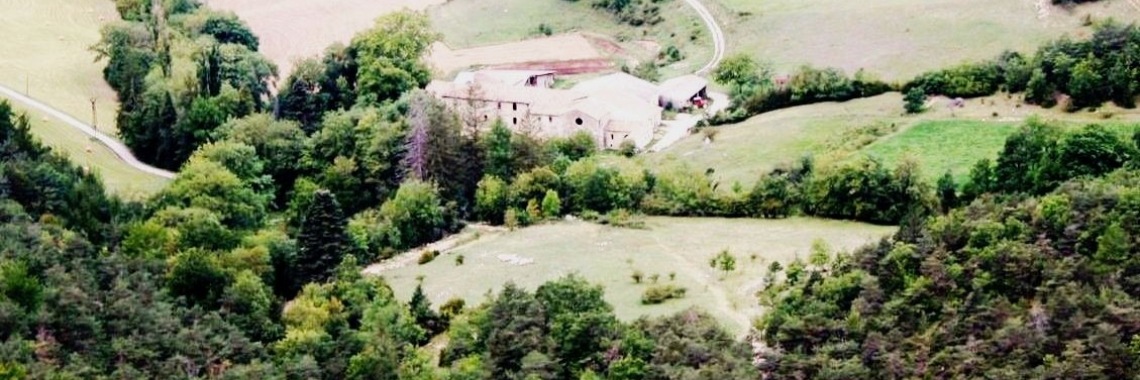
France, Vercors, herbal holiday actually in 1973. Looking at the map I see not only roads, paths and villages, but also personal notes. One day in July 1973 I read, left in Archiane to climb up to the Haut Plateaux du Vercors and then descend to our then residence Abbeye de Valcroissant. What a distance to travel in one day and then I dragged some inexperienced herbal lovers after me. But we did it.
The mini-village of Archiane enclosed by the white straight limestone cliffs of the southernmost part of the Vercors, the Glandasse. We first walk along the Combe d'Aubaise, accompanied by a heat-loving plant growth, lavender, wild thyme, sweet scented mountain stone thyme. Higher up you reach the large cliff flanks of the Glandasse. Fortunately, you can pass through under the overhanging rocks like a tunnel until you reach a carrefour des chemins d'aubaise at 1400 meters. A crossing is a big word for those few paths, but you can definitely go straight, left or right. You turn left, now (1 hour) climb firmly in the reflecting sun until you reach the plateau at 1650 meters. Here in the open plain it is warm and dry, only rock plants and low bushes grow, winding trying to survive. Suddenly the granite Mont Aiguille looms into the distance. The fact that this pounding mountain, once loosened from the mother plateau, has always aroused the imagination of people, is clearly understandable from here. An unapproakable appearance, in its square form rising out of nowhere from the landscape, mighty beautiful.
Beaten from the hand of God, we stare out of admiration for ourselves. But we have to move on, to get home tonight, the Mont Aiguille will remain stoically there for centuries to come.
Hiking on the Glandasse
We walk, just to get poetic back into prosaic, here on the GR 93 on the map this area is called Pleine du roi, but don't expect big names here. At a fork you have to sharply left and again according to the map you now get to the GR 91. In fact, you cross the narrow plateau of the Glandasse, gradually climb to 1900 meters and thus reach the straight edge of the plateau. Far away in the depths lies the town of Die and somewhere a little more south should also be our place of residence. But first we have to go further south, even though to find the passage down in those straight limestone cliffs. From 1900 we must descend steeply to Valcroissant at 690 meters. So 1,200 altitude meters.
Meanwhile, we still enjoy the wild nature to the fullest. Suddenly this roughness is amplified by threatening thunderclouds. Beautiful but possibly ruthless. Fortunately, the clouds feel a little pity for us and the thunderstorm blows over.


then €5.99/month after 14 days
Start your 14-day free trial now to publish your sponsored content. Cancel anytime.